 |
||
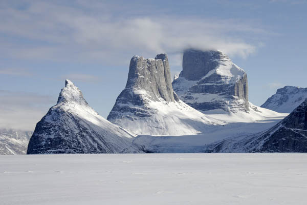
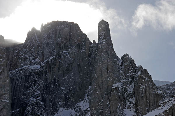
The Sail Peaks in Stewart Valley
Baffin Island Ski Traverse 2007 (Baffin Island's NE Coast: The Fiords)
By Sandy Briggs
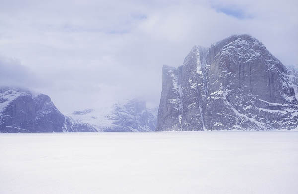
In 1994 John Dunn and I and three friends skied from Pond Inlet to Clyde River in north-eastern Baffin Island as part of John's ‘Baffin Traverse’ expedition. Having found the fiord country awe-inspiring and photographically rewarding, we decided to revisit the area this year (2007), this time with another friend, Paul vanPeenen. While our route was planned to be substantially similar, we would this time travel in the opposite direction, namely south-to-north. A main reason, apart from variety, for this change was that some land that was inaccessible to us on the Clyde River end in 1994 because of lack of snow would, presumably, still be easily skiable if we started there this time. This comment applies particularly to Revoir Pass, which connects Eglinton Fiord and Sam Ford Fiord, and which we could not ski across in 1994. (The following picture shows Eglinton Tower from Revoir Pass.)
We skied more or less west from Clyde River to Ayr Lake and then crossed Ayr Pass to an arm off Eglinton Fiord. Ayr Pass turned out to be a poor route that would not have worked if there had been less snow. The upper part of the descent on the Eglinton side was a steep slope of large boulders. Considerable effort was expended in getting the sleds down this slope, but we really got engaged in solving the difficulties and ended up patting ourselves on the back for a job well done.
The summits were mostly clouded in as we skied by Cockscomb Mountain and the tail Feathers near the west end of Eglinton Fiord. We camped at the base of Eglinton Tower, which was first climbed via the south buttress by Dr T. G. Longstaff and Sir John Hanham on August 21, 1934.
From Eglinton Fiord we skied through Revoir Pass and were lucky to have a clear view of the impressive Fortress Mountain as well as Revoir Mountain on our way through.
In Swiss Bay we saw Kigut Peak (apparently an Inuit word for ‘tooth’), which looks more impressive from this angle than from out on Sam Ford Fiord. We spent a couple of days hanging out in Sam Ford fiord, and the weather was good for enjoying the dramatic scenery of its impressive walls.
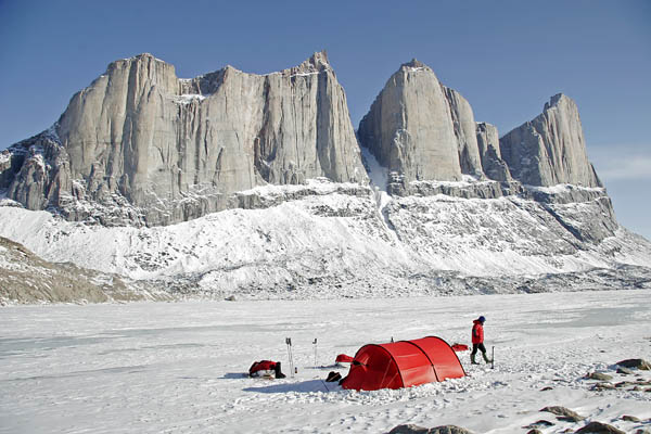
We skied into Walker Arm, past Polar Sun Spire and the Walker Citadel, and on into the Stewart Valley. Here one finds the Sail Peaks, which featured prominently in National Geographic Magazine in January 1999. Across the lake from the Sail Peaks there is a row of more south-facing and shorter walls, one of which had a team of climbers from the Netherlands on it when we were passing by that way. (We had chatted with them in Clyde airport upon arrival.) (The following picture shows Polar Sun Spire (L) and Kigut Pk. (R))
Upon exiting the Stewart Valley we met a group of friends from Vancouver who were skiing with sleds from Gibbs Fiord to Clyde and who were therefore just near the beginning of their journey. This meeting occurred near Mount Longstaff, certainly an alluringly pointed peak if there ever was one.
We grow up believing that water freezes horizontally, but Nature is tricky, and we enjoyed descending to Refuge Harbour on bare river ice that was tilted at a gentle angle, so that the sleds needed no further pulling than that of gravity for a while.
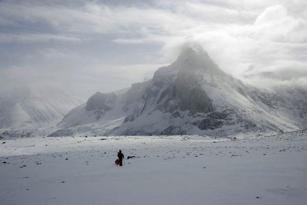
Although the weather was fine for our time in Gibbs fiord, the mountaintops remained largely clouded in, so that our goal of visiting a high cliff-top for photography did not materialize.
We took a leisurely rest day at the SW corner of Sillem Island and then skied out Clark Fiord to look for good valley access to the Bruce Mountains for a land crossing to Dexterity Fiord. There was not enough snow on the land for us to use the same valley that we had descended in 1994, so we scouted a valley further to the east, which led, with a bit of trickery, to the snowy highlands. In the valley bottom on the north side of the Bruce Mountains we came upon snowmobile tracks, indicating that the local folk range at least this far for hunting. Indeed, this valley may be on a good snowmobile route that connects Pond Inlet and Clyde River. (The following picture shows a pillar in Gibbs Fiord.)
Dexterity Fiord was somewhat clouded in upon our arrival, but the greater disappointment was the presence of a deep layer of soft snow on the sea ice. Deep powder snow makes for strenuous sled-hauling, but when it comes, as sometimes on the arctic sea ice, with a slushy under-layer, then one really has some strenuous work ahead. Many of our following days were dominated by the work of pulling the sleds through heavy deep snow. Sometimes we even had two of us ski ahead without sleds in order to break a trail, then returning to pull our sleds to the end of the broken track, and this on horizontal sea ice. It’s no wonder that I managed to drop about 8 kg from my normally desk-bound girth. We were significantly slowed by all the new snow, and we had to abandon a few planned scenic side trips in order to stay on schedule for reaching Pond Inlet in time for our flights south.
By this time we had pretty much reversed our days and nights, so that we were skiing for six to eight hours beginning at midnight or two o’clock in the morning. This phase-shift of the working day has several advantages: the snow surface is usually harder, drier, and better for travel in the cool of the night, the low-angled sunlight is far better for photography, the work is less sweaty than in the sometimes-heat of a full-sun day, and when we stop to camp and make dinner it is the sunny warm part of the day.
We rounded the headland to enter Royal Society Fiord in beautiful nighttime sunshine, but soon faced a bitingly cold westerly headwind that encouraged us to make camp near the entrance to Seal Bay. In the evening the wind changed by 180 degrees to hammer us from Baffin Bay and we found ourselves in a spring blizzard that kept us tent-bound for two days.
Our next sledding day took us over a small isthmus and into Drever Arm, where there was much evidence of avalanches at the bottoms of the steep gullies in the eastern wall of the fiord. The next day we crossed the mouth of Buchan Gulf where we were intrigued on occasion by an interesting mirage effect that likely involved thin layers of warmer air moving across the ice surface from east to west. The result was that images of rock from distant cliffs were seen against a background of the sea ice below.
A kilometre or so from the huge bird cliffs called the Bastions we made camp on the sea ice. After dinner we walked over to the base of the cliff to watch and to listen to the fulmars and gulls vying for locations or mates on the cliff. While there were lots of birds, it was early in the season, and we imagined that the cliff would be much more alive a week or two later.
The following morning was spectacular as we skied beside the cliffs directly into the sun and cast very long shadows along the patterned sea-ice. We stopped numerous times for photography.
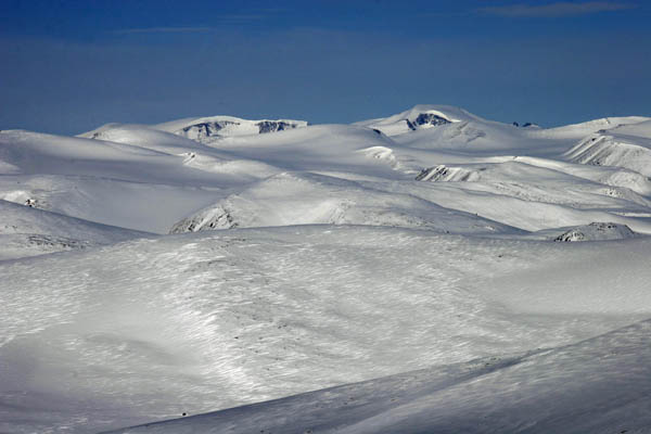
After a camp at an unprepossessing glacier snout west of Cape Jameson we spent a rest day at a fine site west of Nova Zembla Island and hiked up the nearby hill for views over sea-ice dappled by cloud shadows. While returning to camp we happened on a pair of brave ptarmigan who posed for numerous photos. (The following picture shows Qiajivik Mountain, highest mountain in north Baffin, as a large snow dome right of centre and over 30 km distant.)
Having already traversed a bit more of the outer coast than had been originally planned, we rounded the next corner and headed inland toward the snout of the mighty Maccullogh glacier. Our camp that night was a sunny perch atop a high moraine with a commanding view of , well, Baffin Bay. The next day we began the tour around the huge ten-kilometre-wide snout of the Maccullogh glacier, finally camping on the edge of the glacier above a picturesque valley lake. The next morning our run of clear weather came to an end and we groped the rest of the way around the glacier snout in dense fog, passing eerie walls of grey icicles and a mysterious single set of ski tracks. The visibility improved significantly as we descended the valley to the sea ice of Erik Harbour, which we crossed to make camp on Inuutiq Lake, with the thought of ascending westward from there and making our way to the Salmon River and thence Pond Inlet by a completely inland route. But it was not to be. The weather was poor and the cloud very low, so we retraced our steps down the lake’s outlet creek and headed out of Erik Harbour in deteriorating conditions. Wet snow was balling up on our skis and sled-runners, and eventually the slushy wind-driven snow convinced us to make an early camp. (The following picture shows part of the Executioner Cliffs and the entrance to Quernbiter Fiord at the back of Buchan Gulf.)
The next day, in better weather albeit with still-strenuous hauling conditions, we entered Guys Bight. In the estuary at the back of the bight we came finally to a river that showed signs that spring was on the way. The desultory silt-laden open water offered some variety for photography and a chance to ramble looking for migratory birds, which, alas, remained in thin supply.
Stormy weather delayed our departure the next day, but we did eventually get a nice sunny break and, with a determined abandonment of our regular day-night schedule, we made good progress up the glacier and down its side branch – with a roped lowering of the sleds down a steep terminus – to ‘the incredible shrinking lake’. This lake, about 15 km SW of Guys Bight, clearly used to be as much as 50-80 meters higher than it is currently. The old waterline is clearly etched along the rubble slopes far above its shore. The lake seems to fill in the summer and fall, and then drain slowly underground through late fall and winter, with the result that the ice at the shore curves upward as much as a couple of meters from the level we skied on to the level it was at when it froze seven months or so before. This phenomenon leads to a peculiar landscape in which ice is draped along the shore and over boulders and islands in smooth curves that call to mind a Dali painting. We camped in the slushy snow at the margin of the lake, crossing our fingers that there would be enough snow on the land to make our overland traverse to the Salmon River a reasonable one and not a load-ferrying nuisance.
The next morning we managed to sneak up a frozen creek on a narrow ribbon of dirty ice and cross a side-glacier that had actually advanced from its mapped position. Then we did a short portage to regain lake ice and ultimately the creek that would lead us to the divide near the headwaters of the Salmon River. With technical difficulties behind us, and having profited from a few marginal lines of snow that were past their ‘best before’ date, we paused at the high divide for a brief rest. John turned to Paul and me and with meaningful understatement remarked “That could have gone horribly pear-shaped.” To this we chimed “But it didn’t.”
Later the next day we really did run out of snow in the Salmon River valley, so we did a bit of load-ferrying to gain the 400m plateau southeast of Pond Inlet. At that altitude there was still a decent cover of snow, albeit slushy and wet. Our last camp was 10km from Pond Inlet and had a sweeping view of Eclipse Sound. On June 13, our Day 41, we managed to find snow enough to ski down to a road on the outskirts of Pond inlet, where a friend from town came out to pick us up.
We had a bit of time in town to reflect on the privilege of being able to carry out such a journey with great companions who really enjoy being there, and on the privilege of being able to wander for so long with the rhythms of the arctic wilderness.
Sandy Briggs
August 2007
Click here to return to the Sam Ford Fiord panorama.
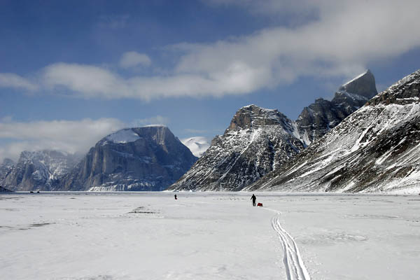
(The following picture shows the Broad Peak group in Sam Ford Fiord from Walker Arm.)