 |
||
A Late-Spring Ski Trek in Tuktut Nogait National Park
Article by Sandy Briggs
Photographs by John Dunn and Sandy Briggs
‘I do not know much about gods; but I think that the river
Is a strong brown god – sullen, untamed and intractable.’
T.S. Eliot
The Dry Salvages I
Wide expanses of brown, snow-free tundra passed beneath the Twin Otter, making us doubt the wisdom of starting a western-arctic ski trip so late in May. Happily, upon landing in the tiny coastal hamlet of Paulatuk we found sufficient snow to eke out a route to the east. Fifteen kilometres later however, just across the still-frozen Hornaday River, the snow-cover abruptly ended. There, much earlier than planned, we huddled in the sleet and rain installing tundra wheels on our sleds. Such innovation and versatility would be the key to our success; and as the saying goes, success is a journey, not a destination.
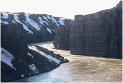 |
Hornaday
River Canyon in full flood, spring 2003 |
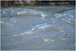 |
||
Caribou
swims Hornaday Canyon in 1.5 m standing waves |
||
John and I had already been on five arctic adventures together, so when my phone rang early one morning last January and he asked, ‘Do you want to go to Tuktut Nogait National Park?’, I just said ‘Yes,’ followed immediately by ‘Where’s that?’
Tuktut Nogait sits atop the tree-line on the Northwest Territories side of the Nunavut border. It was created in 1996 to protect the calving ground of the Bluenose West caribou herd: Tuktut Nogait is in fact an Inuvialuktun term meaning ‘young caribou’. It is one of Canada’s first cooperatively managed national parks, involving the Federal and Territorial governments and the Inuvialuit people.
The geography of the park is dominated by three rivers, the 360 km Hornaday and the smaller Brock and Roscoe rivers. On their journeys to Amundsen Gulf the waters of these rivers, particularly the Hornaday and Brock, have cut spectacular canyons through the otherwise modest topography of Tuktut Nogait. These rivers are Jekyll-and-Hyde characters, asleep through the long winters, in summer mostly lazy clear streams, but swelling with spring's snow-melt to awe-inspiring silt-laden torrents – like the ‘strong brown god’ in Eliot's famous poem. These rivers and the landscape they had created would be the focus of our journey.
By choosing to travel at the height of the melt we would have to adapt our journey to diminishing snow cover on the one hand and rapidly swelling rivers on the other. Indeed, a search of Water Survey Canada’s online river data, as well as correspondence with Tuktut’s chief park warden Christian Boucher, showed that we would be trying to return to Paulatuk at the peak of the Hornaday flood. The complement to these challenges would be the pleasure of witnessing the land return to life – the calving of the caribou, the return of the migratory birds, the emergence of the flowers – and the avoiding of the swarms of insects that can mar the tundra experience in summer.
We camped immediately after installing the sled wheels and spent a rainy
evening keenly anticipating the next day’s field trial of this new
equipment. After breakfast a surprisingly easy kilometer of trundling
brought us to a sweeping view of one of the large meanders in the Hornaday
river, a prospect which momentarily caused our spirits to sink. The nearby
slopes were all bare tundra! Surely, we thought, the higher ground to
the east must still have snow, and we wheeled onward, enjoying the novelty
of it all.
A hilltop camp offered a fuller panorama: the frozen ocean to the north, the now distant village of Paulatuk to the west, the broad Hornaday valley to the south, and to the east the promise of better snow on the Melville Hills. Bonus items in the view included some caribou, two rough-legged hawks, a pair of snowy owls and a mother grizzly bear with two cubs! As a precaution for avoiding visits from “The King of the Barrens” we tried to maintain the habit of cooking and eating away from the tent. Sometimes it was very challenging to find shelter from the strong winds which characterized much of our trip.
The next morning the thermometer read -4°C and a steady wind scoured our hilltop, but the tent had been utterly quiet, with not even a minor flap-flapping to disturb our sleep. We patted ourselves on the back for this masterful display of tent-pitching, only to discover a short while later that the reason for the tent’s rigidity was that it was completely swathed in ice. “Breaking camp” took on a whole new meaning!
The promise of snow held true and we were soon able to resume skiing, but on the warmer days our highway of white was disappearing fast. A reconnaissance side-trip took us to a hill-top, 2200 km due north of my apartment in Victoria, where we leaned into a rushing mass of air that roared by at more than 100 km/h. Fortunately our route in Second Creek valley that day was somewhat sheltered from such winds. We became so absorbed with linking remnant patches of snow that we all but bumped into a grizzly foraging for newly exposed roots. Carrying an injured foreleg, the bear hobbled away uphill, stopping frequently to rest.
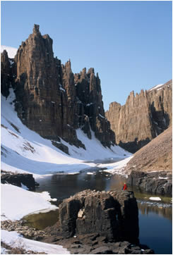
The Brock River canyon was now our immediate goal, requiring a long strenuous day of challenging navigation in blustery and foggy conditions as we climbed up onto the Melville Hills. The canyon looked enticing on the map and it did not disappoint. The Brock has carved an impressive gorge whose buff-colored walls are bedizened with fantastic towers and improbably balanced minarets. On the balconies nest peregrine falcons, rough-legged hawks and golden eagles. From the canyon floor we craned our necks to follow these raptors as they soared along the cliffs high overhead. In the canyon floor it was much warmer than on the plateau, but the river was thankfully still in its gentle just-starting-to-melt stage and our afternoon exploration was sunny and very relaxing. The mild conditions even drew out a single mosquito, one of only four we would meet in three weeks on the land¼.
Park boundaries are often a mystery to those not involved in their creation, and perhaps even to those who are. Tuktut Nogait is no exception. Its western edge has an odd step at this latitude, leaving part of the Brock canyon beyond the park. Hopefully the whole of this fascinating landscape will eventually be included.
We ditched our initial plan to go further east to the Roscoe River, opting
instead to spend more time in areas where the caribou usually calve each
year. So we turned south, skiing across the Melville Hills to the Hornaday
river drainage. At up to 800 m asl, there was still plenty of snow for
hauling the sleds in this higher country. Every day we saw small numbers
of caribou, some with calves, and we were optimistic about finding the
main body of the Bluenose herd. More grizzly bear sightings kept us on
our toes. On two occasions we watched as a bear tried, unsuccessfully,
to catch an adult caribou. It was a sobering reminder of how fast a bear
can run. The ubiquitous Siksiks (arctic ground squirrels) were much more
common victims. Judging by the number of home demolitions that dotted
the land, siksiks must be the grizzly bear's equivalent of candy bars.
One phenomenon really intrigued us. Even on cloudless
days the sky was a pallid
washed-out blue, and in the direction of the sun it was almost white.
We imagine this persistent white haze to be some kind of pollution from
further south¼..smoke perhaps? In immediate practical terms it
had the effect of cutting down the sun’s heat, which made for less
comfortable traveling but at the same time extending our ski season a
little.
Another aspect of global warming surprised us at our camp in a drainage
channel of a long departed icecap: thunder and lightning at almost 70
N! The Inuit throughout the north have reported more frequent occurrences
of electrical activity in recent years.
Once off the hills we made a dash for the Hornaday across a dubious mix of snow and sodden land where no-one in his right mind would have thought of skiing. I was impressed by the way John managed to read the map and the terrain to find a ski route: chasing lines of slushy snow that were well past their ‘use by’ date. Somewhere in the watery maze a short-eared owl glided right overhead for a wide-eyed look at our antics. Jaegers patrolled the skies looking for soggy lemmings. Finally, with John quietly singing a line from the old Eagles song – ‘take it to the limit, one more time’ – we ski-wallowed to the bare well-drained tundra close to the Hornaday. A short sled-wheeling took us to a stunning location on the lip of the vertical-walled canyon. Our expectations were confirmed: the frozen trickle of a river that we had skied across on our first day was now charging past 100m below us, a powerful and intimidating muddy torrent. It was June 7th and 12°C. The freshet was in full swing and our options were clearly limited. We would have to make our way down the right bank of the Hornaday and attempt to cross it below the canyon, where we hoped its wild energy would be exhausted as it meandered in a calm and civilized manner to the sea.
The following day we hiked down to an accessible section of the river
to get a closer look at a narrow run of huge standing waves and a better
feel for the sheer power of the river. As we watched ice-pans being swept
along we were stunned to notice several caribou in the fast-moving water.
Having missed a good exit point they were returning to the other side,
right through the largest crests and troughs of these two-meter waves!
We were certainly agape at their swimming ability and at their skill in
reading the river once they were in it, but we shared some skepticism
about their ability to choose a good crossing place. Instinct must have
got the better of them. Certainly we would have to find a much tamer reach
for our crossing a few days hence.
Post-trip information from the chief park warden indicates that the Bluenose
West herd calved and moved on earlier than usual in the spring of 2003,
and also that most of the herd did not make it to the usual calving ground
north of the Hornaday, with many calving at the southern end of the park
instead. That's why we'll have to wait till another trip to experience
the thundering hooves of the mass migration.
With the flood season fully upon us we were forced
to continue our downstream journey occasionally far from the main river.
Only in this way could we successfully cross the several major tributaries
which cut their own inaccessible side canyons as they joined the Hornaday.
A few remnant lines of snow amongst the hills helped us squeeze two more
days of slushy skiing out of the landscape. As a result of uncertain footing
one of my skis broke in half and was not worth fixing, so I hobbled along
behind John until, inevitably, there was no more usable snow and we reverted
to sleds on wheels.
The work was very hard but also rewarding and fun in a perverse way. The
weather turned cold and cloudy, which prevented the melt from getting
completely out of hand, but it made for some pretty chilling moments.
We crossed innumerable streams, employing every technique in the book
plus a few more. Crampons provided traction when fording the creeks that
still had iced bottoms. At one slow and narrow but very deep slough we
ferried ourselves across on a floating sled while the wind-chill turned
the rope crunchy with ice. At another cold gray tributary we waded in
up to our ribs, each with his sled gripped tightly in the downstream hand
and a sense of humour firmly entrenched. On June 10th we made a 5 km side-trip
to visit the eagerly anticipated La Roncière Falls. In the park
literature it is a picturesque white cascade tumbling into clear blue-green
pools. In freshet, as we found it on this windy June afternoon, it was
turbulent brown chaos hurling spray plumes upward for its entire 20 m
height.
The Hornaday is not all power and intimidation. Above the canyons the river has 145 km of gentle water which make for an easy July canoe trip. Apparently the entire canyon (except, of course, the falls), with its succession of class IV and V rapids, has been paddled only once, by a pair of expert white-water kayakers in 1999.
We resumed our westward wheeling journey, seeking the flat stony plateaus and shunning, where possible, the much more difficult fields of wet grass tussocks. On the morning of the 11th the thermometer was at -3°C. That’s not very cold, but it’s cold enough to freeze boots and socks that are saturated with water, so we ended up holding them over the stove to thaw them enough to wear. After another long and cold but productive day we reached a windswept ridge and a view of the lower Hornaday river. A herd of 15 muskox on the opposite bank managed somehow to appear pastorally content despite the bitter wind. Perhaps they appreciated their luck at being so far “south”, compared to the muskox eking out a living in the polar deserts of Ellesmere and Devon Islands.
Our theory about the mild-mannered meanders was looking good and we began
the day-long process of preparing for our crossing of the 200-300m wide
river. To one sled we attached inflatable pontoons, a tried and tested
system previously used on our journeys on Devon and Baffin Islands. The
resulting craft at least looked like a boat, which is more than can be
said for our second creation, affectionately named 'Bob': a sled mounted
on both sets of wheels. Tests at the river’s edge showed that we
had enough combined flotation to transport both of us and all our gear
across in one trip. I was to go in 'Bob', armed with a good dose of bravado
and a paddle made from my now defunct skis. After much re-packing, double-checking
of equipment, and discussing of procedures – during which a couple
of passing snow squalls reminded us not to become complacent – we
launched into the river, with John out ahead and with a floating line
between us. The sun burst through the dull overcast to herald the occasion,
and in a surprisingly easy 10 minutes we were safely on the other side
with big smiles and ‘high fives’. Everything had gone swimmingly
well.
Now on the Paulatuk side with the crux of our route taken care of, we relaxed mentally and set about savouring the last few days of our multi-media northern journey. John paddled serenely down the lower Hornaday with the four-wheeled freight sled (Bob sled) bobbing along behind, while I hiked in warm sunshine along the high banks photographing ptarmigan, getting chastised by peregrine falcons, and enjoying the luxury of not pulling a sled for one day. At day’s end we met at exactly the place where we had skied across the river three weeks before, thereby closing the loop on an exceptionally fun and challenging trek.
Tuktut Nogait National Park ( 16340 km2 ) is almost as big as Banff and Jasper Parks combined ( 17520 km2 ), and it may soon be extended eastward into Nunavut. If you go there you will likely be alone. Last year’s visitorship was in the very low single digits. Watch out for bears. Be ready for wind and water and ice. Be ready to lose yourself in the magical flow of an arctic adventure that will nourish you for the rest of your life.
 |
Lower
Brock River Canyon, NWT |
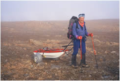 |
Sandy
with John's sled-wheeling innovation. Tuktut Nogait National Park,
Spring 2003 |
 |
||
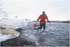
Sandy
fording a cold creek, a tributary of the Hornaday River, Tuktut
Nogait National Park NWT |
||
 |
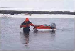
John
Dunn fording a creek with a wheeled sled. Tuktut Nogait National
Park. Spring 2003 |
 |
|
Sandy
in Brock River Canyon, Tuktut Nogait National Park, spring 2003 |
|