 |
||
 |
To the Ragged Edge of the
World Sandy Briggs A shortened version of this article appeared in the Summer 1999 issue of Canadian Geographic Magazine. The polar bear we had encountered only minutes earlier was, to our relief, now ambling away southward as we watched intently from our rocky outcrop, waiting for the coast to clear. Just as we began to relax a second bear appeared, approaching us from the ice-edge along an old set of tracks. With a mixture of apprehension and awe we observed each pause and turn of the head as this graceful hunter reached the bottom of our lookout, caught our scent, and, after a moment's consideration, changed course to the north. I had to put down the binoculars occasionally to reassure myself that he was not already close enough to pounce. Meanwhile John, ever vigilant with the telescope, remarked "It's getting a bit thick out there. I've just spotted a mother and two cubs!" North and south to the limits of our view stretched the land-fast ice, our sledding highway around eastern Devon Island. The ice-edge, here less than one kilometer from shore, was sharp against a background of dark water, and the snow glowed a soft magenta in the low-angled sunlight of that magical arctic evening. The edge of the ice marks the boundary between our world and that of the beluga, the narwal, the walrus and the seal. The white bear crosses back and forth with ease. Watching those bears was one of the most memorable experiences of my life. The first bear, a big shaggy fellow with thick folds of skin, would dive into a lead (an open crack in the ice) and then emerge with a shake further along. The second would pause and sniff at the air, presumably for seals, then continue his unhurried pace - unchallenged master of his environment. Our one regret was that in our rush to reach higher ground we had neglected to take a camera. After an hour we resumed sledding and hauled a vigorous seven kilometers southward keeping well back from the ice-edge, finally resting near some blocks at the front of a tidewater glacier. No sooner had we voiced self-congratulations at having passed successfully through the concentration of bear activity at Johnson Point than a sixth bear emerged suddenly from behind an ice block. He gave us only a brief glance, then disappeared. Exciting though it was, I frankly wished for not too many more six-bear days. In the fall of 1997 John Dunn had asked
"Would you like to go on a ski trip to the edge of the world?"
OK, that's not exactly what he said, but well he might have. Devon
Island is the largest uninhabited island in the world (55,247 km2).
Its black talus slopes define the northern shore of Lancaster Sound,
entrance to the famed Northwest Passage. A huge ice-cap, far higher
than any of the surrounding mountains, weighs down the land and
oozes like a perversely white treacle from between the shattered
cliffs to merge with the frozen ocean.
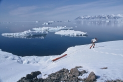
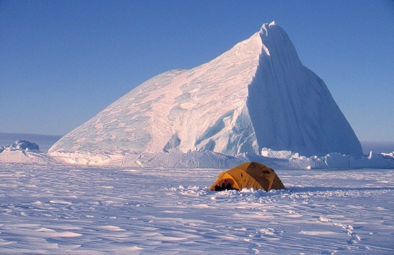
The raw uninhabited wildness of Devon Island is its attraction for two city-dwelling adventurers. Our ski-crossing from the Franklin memorial at Beechy Island to Sverdrup Inlet in 1992 had taken us through an interior plateau of snow-covered shales so featureless and devoid of life that we had taken to calling it the Empty Quarter after the legendary desert of the southeastern Arabian Peninsula. This time our objective was to seek the edge of the ice. Where sunlight can enter the open water and currents stir up nutrients from the bottom, conditions are right for an abundance of ice algae, plankton, tiny squid and fish. This richness attracts all things higher in the food chain, the sea birds as well as the seals, walrus, whales, and the polar bears. Therefore the ragged edge of the arctic world, far from being desolate, is a place of abundant life. The ski-wheel equipped Twin Otter dropped us off in front of the Sverdrup Glacier on the north coast of Devon Island on the pleasantly sunny evening of May 16, 1998. John and I had passed this way six years before, but the ghostly breath of earlier visitors was on the wind. In 1852 Commander Edward Inglefield sailed here in search of the lost Franklin Expedition. He wrote, "Rapidly we sped before a freshening gale towards the eastward, and eagerly did our glasses scan the shore, but it was all in vain, no trace of anything human could we observe, all was a mass of ice." Only fifteen kilometers to the NW lay the bleak and exposed site at Cape Hardy where Dr. Frederic Cook and his Inuit companions Ahwelah and Etukishook spent the winter of 1908-09. They hunted musk-ox with a lasso and lances, and fended off polar bears from their 'renovated' pit house, a re-occupied relic of an age long past. That spring the three men continued north and crossed to the village of Anoatok in Greenland, thus completing one of the most amazing journeys in the history of Arctic exploration. This notwithstanding the fact that Cook's subsequent claim to have achieved the North Pole during that journey is widely discredited today. We skied off in the metaphorical wake of Bylot, Baffin, Inglefield and others, slowly at first, being neither in a hurry nor fully acclimatized for the real work that would soon enough come our way. The very useful reference book called Arctic Canada from the Air describes Devon Island as a "legless donkey with its head thrown up to bray". The Devon donkey is headed west, while we two lesser asses of a different sort skied eastward toward its hindquarters. So began the 'Legless Donkey World Tour 1998'. On the tenth day we stood at Belcher Point, beside open water for the first time. Eider ducks swam back and forth, calling occasionally. A set of fresh bear tracks reminded us to be alert. The smell of the cold salt sea and the stark contrast of white snow against black water brought back memories of other arctic journeys, but here the sheer size of the nameless bay and the slightly hazy prospect of the surrounding glacier-draped mountains were completely overwhelming. Devon's NE corner, Cape Caledon, appeared impassable on skis, so we detoured up a large glacier toward the ice-cap in order to by-pass the open waters of Lady Ann Strait. On the second day up the glacier snow began to fall, and it continued with few breaks for two days, accumulating over 30 cm of new powder. Whereas before we had ascended the glacier with both hauling each sled, and therefore making three trips at every stage, we now were forced to ski ahead and break trail uphill without the sleds and then return for them one at a time, for a total of five trips over each stage. At this rate the camps were only four kilometers apart. We began to deride the notion of this place being a polar desert. On the fourth glacier day the weather cleared and we enjoyed brilliant sunshine as we skied across a very broad and subtle pass at 3200 ft (the maps we used are in feet) on the ice-cap to end the day with our tips pointed downhill toward the sea-ice once more. Three days later on a cliff-top overlooking Baffin Bay we gazed for hours as beluga and narwhal cruised back and forth, now and then diving for food below. A bear swam toward us and climbed out onto the ice. He hunted a while below our viewpoint, then disappeared.( We wondered what might be happening to the sleds in our absence. ) There is something very special, as John remarked, about having one's horizon compass a wilderness half the size of England. To the NW, Cone Island, Smith and Ellesmere Islands marked the end of our 1992 expedition and John's 1990 Ellesmere traverse. Due north lay Coburg Island, a shimmering fairyland of ice and mountains (and a protected National Wildlife Area). Just east of Coburg lies a tiny peaked island called Princess Charlotte Monument. It is barely 200 ft high, but the miraging that night made it loom like several stacked CN Towers across fifty kilometers of icy ocean. After the concentration of bears at Johnson Point we made our way to the back of Hyde Inlet, where a determined ramble over windswept wetlands revealed the first muskox we had seen since donning our skis three weeks before. Our trek down the east coast of Devon Island involved several days of travel in fog. While not as dangerous for us as for the early sailors, we nevertheless missed the fine views, and we had to be more vigilant about navigation and about bears. One evening in thick fog I led us into a frustrating maze of icebergs calved from the ice-cap edge, between them a swamp of slush and water that floated the sleds and lapped at the tops of our gaiters. In Queen's Harbour, a small bay on the southwest coast of Philpots Island, we pitched our tent on the site where British whalers G. Brown and E. P. Philpots and the crew of their ship Queen wintered in 1865-66. Their eagerly-awaited release from the ice came eventually on August 27th! While Philpots apparently had the appetite for a second winter in the neighbourhood of Lancaster Sound the crew did not. "... but we had not proceeded far before the crew mutinied, and we turned back..." he reports. We found, on the slope behind our tent, a mound of rocks we believe to be the grave of at least one of the Queen's crew.
Good sea ice, but more fog, brought us to the southeast corner of Devon Island, Cape Sherard. Three lonely orange cabins remain from an ice-observation project of twenty years ago when the notion of oil-tanker traffic in the Northwest Passage rated higher than it does today. During a windy scramble up the prominent Hope Monument we discovered only rock walls and pieces of aluminum wire marking the site of a lookout shelter where a friend of mine spent some time at what must rate as one of the most bizarre summer jobs of all time B watching icebergs go by. Entering Lancaster Sound we again encountered open water close to shore and were treated to the expected but always fascinating sightings of beluga, as well as many eider ducks and black guillimots. A gyrfalcon perched nobly on a rocky outcrop above the lowland meadow, waiting perhaps for one of the numerous arctic hare to relax its watchfulness, or for a ptarmigan to reveal itself by simply moving.
Muskoxen became a common sight as we neared Cape Warrender, the anticipated crux of our journey. Here wind, tide, and southern exposure remove all ice from the shore earlier than elsewhere, making progress tricky for a sledding expedition. In the event we were able to round the cape on ice, but only by dint of hard work with the ice-axes and some load-carrying. Walrus and beluga swam by as we chopped and shifted ice blocks in the pressure-jumbled ice-foot. (The ice-foot is the strip of sea ice that is frozen to the shore and which does not rise and fall with the tide. Often it is wide enough for travel, and has been referred to as the arctic highway.) Perversely the dreaded Cape Warrender turned out to be very engaging, even fun. Slowed, however, by the need to carve a road, we gained only four kilometers in nearly eight hours. We made camp in the late afternoon as heavy wet snow began to fall. Alas poor weather and a concern for our timetable prevented us from scrambling up any of the local mountains. Two days of snow and rain saw us ferrying heavy loads along a rocky bench 300 ft above the water to reach the next small bay. We had arrived late, and there was no longer enough ice-foot to support a ski expedition.
Next day the sun came out and so did the pontoons. Four years before in Baffin Island we had experimented successfully at converting the sleds to rafts, so we had brought one set of shortened inflatable tubes for the eventuality of having to cross wide leads. Now, however, we pressed the sled-raft into service as a coastal ferry, saving many shuttles with loaded backpacks. The problem of Cape Warrender had been solved, and we happily skied across the remnant ice of Johnson Bay and into Dundas Harbour Post on June 20th, the 36th day of our trip. The happiness was partly for having reached this historical way-point, but partly also for having done a laundry and had a wash that morning in the all-too-severely rationed sunshine of southeast Devon. Dundas Harbour began as an RCMP outpost for the exerting of Canadian sovereignty in 1924. One can only imagine the physical and psychological difficulties faced by the young mounties posted there, having no contact with the southern world from one summer to the next. The small cemetery on the hill behind speaks of several deaths, at least one a suicide. Yet there were also those who thrived. Staff-Sergeant (later Inspector) A. H. Joy has rightly become legendary for the amazing patrols - expeditions really - that he and his RCMP and Inuit companions accomplished in the last half of the (elsewhere >Roaring') Twenties. The RCMP Commissioner's Report of 1926 tells of Joy, Constable Dersch, and the Inuk Nookapeeungwak setting out from the Craig Harbour Post on Ellesmere Island with two teams of dogs in a gale on March 22nd. They crossed Jones Sound, then waited two days for the storm to abate. After thorough reconnaissance they ascended a glacier south of Belcher Point to begin a crossing of the Devon Ice Cap. The crossing went well enough, but while descending the glacier toward Croker Bay on the south coast they had a high-speed encounter with hidden crevasses, in which one of the dogs was lost. Four days later they set off from the Dundas Post, this time with Constables Anstead and Maisonneuve and the Inuk Klishook. The six men crossed the ice cap again, this time going north, after which Anstead and companions went directly to Craig Harbour, while Joy and his team detoured westward to visit Cape Sparbo. Joy wrote "I have described the route taken by this patrol somewhat minutely so that in the event of it being made in the future by strangers ... a comparatively easy trip can be made." John and I were among those future 'strangers'.
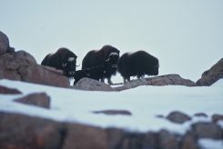
The RCMP vacated the Dundas Harbour Post in 1933, whereupon it was taken over by the Hudsons Bay Company. In 1934 ten Inuit families were moved there from Baffin Island with the intent of setting up a fur trading post. The site had been poorly chosen, however. It was exposed to fierce winds both off the water and off the ice cap. The sea ice was subject to too much motion in winter and break-up was too early in spring, so the ability to travel long distances for hunting and fishing, and for visiting other communities, was very restricted. Moreover, the relatively narrow coastal strip of eastern Devon Island not actually covered by ice was neither large enough nor rich enough to support adequate wildlife, especially arctic foxes, to sustain a multi-year trading post. In 1936 the Dundas Post was vacated again, but not before the crossing of the Devon Ice Cap had been repeated by Post Manager Chesley Russell and three companions. The Dundas Post was occupied again from 1945 into the early 1950s, but now stands abandoned, an important historic site but alas also (in 1998) a disgusting garbage dump. On the day of our visit the weather was kind, and, ignoring for the moment the dilapidated buildings and scattered oil drums, we saw a verdant meadow with arctic hare and musk-oxen grazing. A long-yailed duck called from a pond surrounded by a field of green, while a pair of rough-legged hawks perched on the cliff above, intermittently circling and crying out at our intrusion. Our plan was to cross the ice cap northward, a human-powered repetition of Inspector Joy's historic patrol. Skirting the remnant edge of the shining ice-foot we made our way westward into Croker Bay, its still-frozen expanse a welcome change from a week of wading, load carrying, and ice-road construction. Just before reaching the bay we had our most engaging polar bear encounter. A lone male huffed and snorted at us from less than 100m. At last, more annoyed than frightened at our noise-making, he slowly turned and grudgingly plunged into the dark sea, later to emerge on a large flow some way off shore. A reconnaissance day at the head of Croker bay found us a way to get onto the giant glacier to begin our ice-cap crossing. The day also provided an unexpected opportunity to watch a mother bear and two cubs frolic in carefree ignorance of our presence. Expect the unexpected and wonder is around every corner! Although most of the glacier front is ice-cliff we were able, the next day, to haul the loaded sleds up a gully by means of a pulley system, thereby avoiding tedious load-ferrying. Before long we were established on the bare glacier ice, and we then made good progress amongst a few crevasses to the smoother ice above. Heavy rain delayed our start the following day, but late in the afternoon we set off, soon to encounter large areas of rushing melt-water creeks and calf-deep slush-fields; challenging sled-hauling indeed! It seemed ironic that the glacier, this part at least, was actually wetter than the sea-ice. We camped at 3100 ft as the sun came out again. John switched his attentions to photography as I decided to remove the flopping shambles of multi-layered tape from my feet to give them a night open to the air. They looked to be in rough shape, but were in fact doing pretty well. The weather stayed clear and sunny for the remainder of our ice-cap crossing, which we nevertheless hastened by putting in a record 44km day to pass the trip's high point at about 5300ft. As we skied down the gentle north slope we crossed a relatively fresh set of bear tracks at 5000ft. He was headed east toward the top of the great ice-dome. Two days later on June 30th we carefully walked the sleds down a steep ice ramp at the snout of the Sverdrup Glacier, thereby closing the loop we had begun 6 2 weeks before. We were wearing big grins and the warm sun was beaming down. A few hours later we pitched camp in a lush meadow of green grass and yellow poppies B a marked contrast with the windswept and snowy monotones I recall from our camp here in 1992. A fox with a young kit skirted our camp. A quick scan with the scope revealed at least twenty musk-oxen on the slopes behind. It was another one of those wondrous arctic nights when one doesn't want to go to bed! Over the next three days we made our way westward, around Capes Hardy and Sparbo, to reach the unoccupied biological research station at Truelove Lowland. This proved tricky, as we had truly stretched the sledding season to its limit. The sleds became boats again for the final going ashore. As we dropped our last loads of gear in that odd little research ghost-town the Arctic gave us one last surprise. Near the rough airstrip grazed two Peary caribou (Rangifer tarandus pearyi), lonely members of an endangered population. Until then we had seen no caribou, only weathered antlers wedged among the rocks. We had come to Devon Island with a goal
and we had accomplished it. But that goal is just a pencil-line
on a map. The real journey is the sweat and the sunshine, the fun
and the toil, the encounters with wildlife and weather, the ability
to touch gently the wide wilderness, and, for me, the pleasure of
traveling with a friend who truly carries the explorer flame to
the ragged edge of the world.
|