The
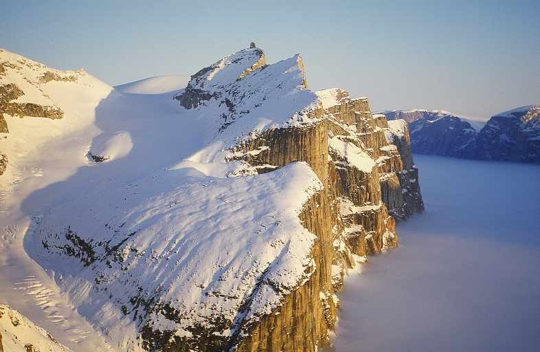
picture shows a view of a cloud-covered Gibbs Fiord late at night.
It remains one of the most spectacular places I have ever been.
First published
in the Island Bushwhacker 1994 Annual
Baffin Traverse ’94
Sandy Briggs
TThe land of the Inuit is
an immense one with few people. This land, like all land, is indifferent
to our puny presence. Like the Inuit, we are on the land, but unlike
them we are not of the land. Our relationship with it is a romantic
one, one of struggle, adventure, escapism, sport [1]. Our lives
are enriched by the land but our life comes not from it. We are
visitors. In Sam Ford Fjord we meet hunters who invite us to their
camp for tea and boiled seal. John explains the nature of our project,
a human-powered north-to-south traverse of Baffin Island. He explains
that our sleds contain all our food, brought from the south, that
we will travel about six weeks between re-supply points, and that
our next cache of food is in a refrigerator in Clyde River. The
laconic reply of one of the hunters delivers more meaning than I
had thought possible in only three words, “Food is everywhere.”
The project was born several years ago in the imagination of John
Dunn, a photographer, lecturer, and Arctic aficionado who was then
based in Calgary. He dreamed of assembling a team to travel under
its own power along the length of Canada’s eastern Arctic
seaboard, from the northern trip of Ellesmere Island to the tree-line
in Labrador. The Ellesmere Island section was completed in 1990,
and in 1992 John and I traveled from Resolute Bay across Devon Island
to Grise Fjord to complete the second stage. In 1993 John and two
others skied from the northern tip of Labrador to Nain. The final
(1994) segment of the traverse would involve a total distance of
3,000 km. and require six months.
John, Mike Sharp, and Bob Saunders set out in late March from Cape
York, Baffin’s northern tip, and skied through a period of
cold but fine weather to the town of Pond Inlet, where Graeme Magor
and I joined the expedition on April 28th. With sleds weighing upwards
of 110 kg we set off the next day for Clyde River, eager in anticipation
of skiing through the spectacular fjord country of northeast Baffin
Island.
Swish, swish, swish – I ski. The sled follows. Legs and arms
and lungs and heart strengthen and flow over the glistening land.
The movements are mine, but the journey itself is a separate thing,
alive, like an animal. It cannot see itself, but only wakes, and
travels, and sleeps. The animal slides over the snow, over glaciers
and frozen lakes. It crawls into an ice-cave to wonder at giant
crystals of hoar, an arched ceiling of fragile jewelry, pillars
and plates and daggers and fish skeletons, variations of the magical
hexagon that is water in the solid state.
Emerging from the cave of ice, the animal slinks into the mountains
and upward to the highest point in north Baffin (Peak 6440, N 72
degrees 10.8’ W 75 degrees 55.7’) [2]. From this sunny
dome one enjoys a panorama of a land and a sea locked in ice. Rounded
hills, smooth and white, march toward Baffin Bay, while southward
lie steep-walled fjords where soon the journey animal will crawl.
Did I say crawl? For two days in Coutts Inlet there is no crawling,
instead a wild flight before the wind. Brightly coloured sled-sails
bulge to fling our loads along the ice in an ungainly and delirious
race, a race almost to see how much of life can at once be lost
and won in the flowing moments that swirl about the journey like
the spindrift itself.
From fjord to fjord across isthmus and ice we glide and walk and
push and strain and laugh and eat, until our now too unfamiliar
friend, the sun, returns to work its magic. Gibbs Fjord becomes
a gilded corridor of wonder. A night of day upon the precipice above
a sea of cloud connects the eyes directly to the soul and reminds
again, insists, shouts – so loudly that the tears come even
now – that there is so much to share, so much beauty to share.
Mere photographs will prove but feeble tools for this.
Our visit to Clyde River proves more valuable than we could have
imagined. We participate in a variety show for the school kids.
We laugh and cause laughter, and feel touched by the community of
people through whose land our journey wanders. Graeme’s holidays
have ended and he has to leave us here, but his Monty Pythonesque
humour lingers.
Southward the land is flatter. We link patches of rapidly disappearing
snow across the Henry Kater peninsula and start island-hopping in
Home Bay. The meltwater has nowhere to go, so it lies on the ice
making slush and giving a whole new meaning to water-skiing. But
the animal lives by its movement, and so splashes its way onward
into Okoa Bay to begin the crossing of the Penny Ice Cap. Day upon
day of wet gray skies, punctuated by what seemed only brief moments
of spotlighting on icebergs, give way to clearing weather as we
gain the glacier. Struck once again with wonder, we eagerly take
turns peering through the telescopes as a mother bear and her two
cubs frolic and mock-wrestle on the other side of the fjord. Four
days of good conditions and we are across the ice-cap. We remove
the skis for the last time. Now 35 km. of summer landscape separates
us from Shark Fjord, the site of our next air-lift of supplies.
The “secret weapon” is deployed! We mount the sleds
on pontoons to make a raft, then float down the river. Well, almost.
The river is mostly too shallow – the animal drags its belly
in the cold silty water – and soon becomes an impassable canyon.
Tundra sledding and much load-ferrying get us to tidewater on July
12th, three days ahead of schedule. The air temperature reaches
20 degrees Celsius.
The pilot arrives with our folding kayaks and more food. He takes
away the sleds and skis. The seven meter tidal range and wide boulder-strewn
intertidal flats make for an interesting loading operation, but
all goes well in the end, and the pleasure of receiving mail from
friends is the ample reward for the day.
After two days of sewing and sorting, packing and patching, we are
almost surprised that everything will fit in, and on, the boats.
Our journey, now become amphibious, swims cautiously across the
back end of Cumberland Sound, portages and hops lakes across to
Nettilling Fjord, and then, midst a swarming maelstrom of mosquitoes,
makes its way to Nettilling Lake. Gray skies and rain, the tinkling
music of candle-ice on the shore, and the presence of a fresh-water
ringed seal lend an air of mystery to the place. The expedition
animal has followed a traditional Inuit route to this 5,000 square
kilometer inland sea, where now we must push aside the lingering
winter ice in order to advance.
The west side of this great lake is the edge of the Great Plain
of the Kudjuak, a low rolling expanse of tundra and water rich in
caribou, geese and many other species. Returning mesmerized from
an evening stroll, Bob calls it the Serengeti of Canada. On August
7th I pass the 1,000-mile mark.
Blackflies swarm as we tackle the final challenge of this, the fourth
leg of the traverse. We must ascend the Amadjuak River to the large
lake of the same name. So, into a final week of mainly sunshine,
frustrating portages, lining the kayaks up moderate rapids, paddling
flat-water sections, and marveling at the clarity of the water.
The river keeps us guessing. I am openly nervous. John is openly
confident. Mike and Bob are in between. Once, while nosing a kayak
around a corner with ropes and all hands on shore, we allow the
bow to get caught. The boat is immediately flipped up and the cockpits
fill with water. Were it not for the sea socks in the cockpits we’d
have lost it. In spite of this sobering lesson, we repeat it a day
or two later.
We try to leave the river and connect a series of small lakes. One
day we do eight portages, one of over a kilometer. So it’s
back to the main river, with respect. We are putting in long days.
Steadily the animal gropes its way upstream. We make blackfly paste
in the folds of our clothing. On August 16th we arrive at a long
spit in the north end of Amadjuak Lake, one day early for our re-supply,
and the end of the line for me. We have paddled nearly 500 km.
August 17th is a day of sorting and repairing, planning and reflecting.
The plane comes, bringing Glen Cowper to replace me in the kayak,
and more wonderful mail from friends. The team will paddle and portage
to Lake Harbour on Hudson Strait, where the kayaking ends and where
Mike and Glen will leave for the south.
I am not sad to be going home, but I am sad to leave my friends
before the project is complete, before that greater animal, the
journey, has reached its goal. Up close the land is alive. From
the plane it is a vast stretch of featureless sameness, a patchwork
of brown land and blue water in the rain. Appearances can deceive.
October 4th. John phones from Montreal! He and Bob reached the southeast
tip of Baffin Island after a long hard hike over rough boulder slopes,
through deep new snow, and having had two close bear encounters.
The journey, alive like an animal, reaches home.
[1] Paraphrase of Walter Bonatti.
[2] See CAJ 58 (1975) p.95ff
|